


The photos of the lot are informative and indicative, and cannot provide a highly detailed view of the object from all angles. We recommend a careful physical inspection of the lot before bidding.
The photos of the lot are informative and indicative, and cannot provide a highly detailed view of the object from all angles. We recommend a careful physical inspection of the lot before bidding.
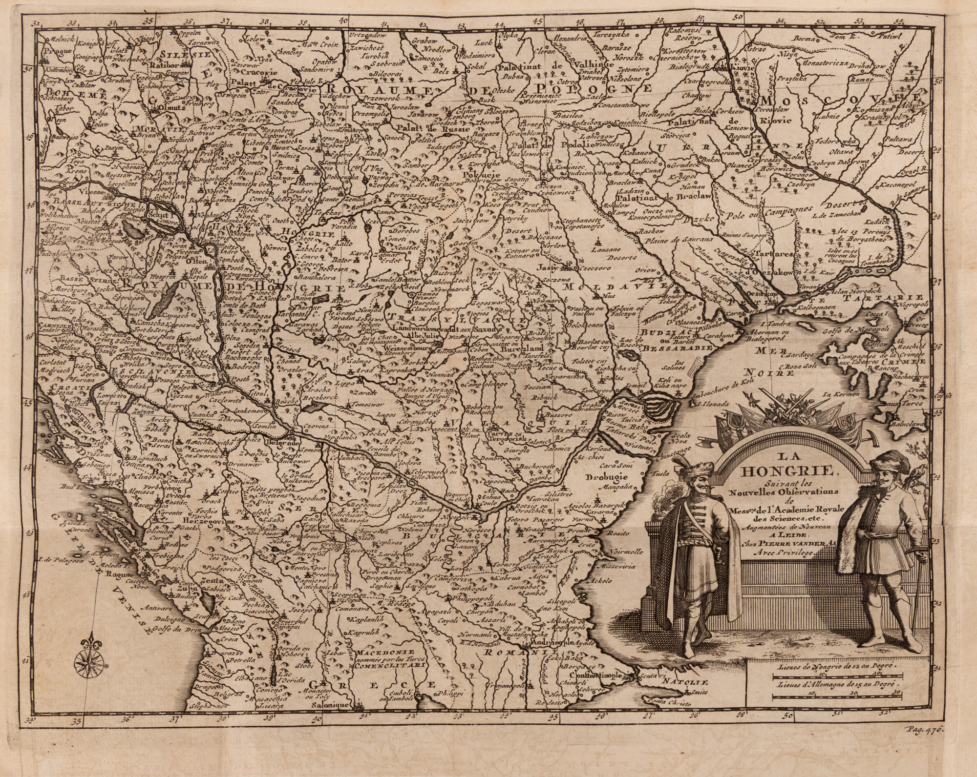
196. "Map 'Hungary', along with the Romanian Countries, by Pieter van der Aa, Leiden, circa 1714"
Starting price
Pretul de pornire si cel estimat nu sunt preturi de vanzare efective
EUR 200
Session
Wed, 1 July 2026 19:00
0 Zile, 18 Ore, 37 Minute
Time remaining until live auction starts
Brought to you by
The original title, "La Hongrie", identifies the main territory represented, but the composition extends over a much larger area of Central and South-East Europe. Alongside the Kingdom of Hungary, Transylvania, Moldova, Bessarabia and Wallachia are depicted in an overview that allows the observation of geographical and political relations between these provinces at the beginning of the eighteenth century.
Territories, borders and main urban centers are represented through a meticulous network of routes, names and conventional signs. Mountain ranges are pictorially represented, by successions of stylized shapes, and watercourses structure the composition and highlight the importance of the Danube and its major tributaries. The numerous toponyms transform the map into a veritable visual archive, where one can track historic names, cities, fortresses and regions whose borders were to be modified in the following centuries.
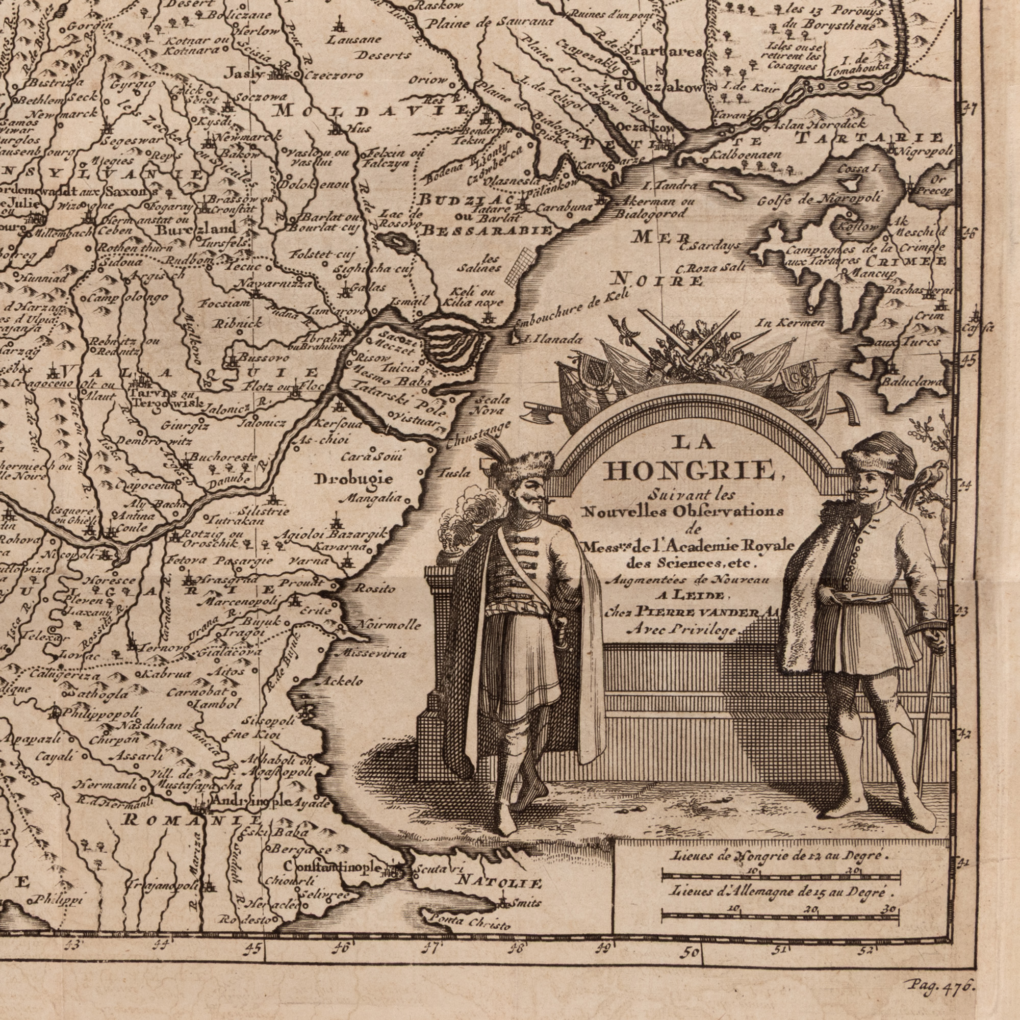
The ornamental cartouche gives the work a pronounced artistic dimension. Specific to the Baroque taste, it turns geographical information into a decorative composition, designed not only for consultation, but also to impress the viewer. The fineness of the lines incised in the copper plate, the balance between inscribed surfaces and geographical areas, as well as the texture of the laid paper retains the charm of the objects printed in the great European workshops of the time.
The map was published at a time of profound transformation of the region. After the conflicts between the Habsburg Empire and the Ottoman Empire in the late seventeenth and early eighteenth centuries, Central Europe and the Romanian territories were at the center of Western political and strategic concerns. Seen today, the piece not only offers a geographical representation, but captures the way in which this border space was known, ordered, and imagined in the West.
Beyond its interest for collectors of old cartography, the map appeals to enthusiasts of history, travel, genealogy and European culture. For a viewer originating from one of the territories depicted, it offers the rare experience of discovering familiar places through the perspective of a cartographer from over three centuries ago.
Through its graphic elegance and the wealth of historical information, the work can be a point of attraction in a library, an office or a contemporary interior. It is equally a document, a graphic work and a decorative object: an image of Europe of old and a testament to the era when the map was one of the most spectacular forms of knowledge of the world.
Dimensions
width 23.5 cm, height 24.5 cm
Description
copper engraving, 23.50x24.50
ADDITIONAL INFORMATION
For clarifications regarding the bidding procedure, hammer price costs, guarantee, payment, and collection terms for the winning lot, we recommend carefully reading/re-reading the Bidding Regulations.
For additional information regarding the lot and the auction, please contact the Art Consultants Department.
Detalii
The original title, "La Hongrie", identifies the main territory represented, but the composition extends over a much larger area of Central and South-East Europe. Alongside the Kingdom of Hungary, Transylvania, Moldova, Bessarabia and Wallachia are depicted in an overview that allows the observation of geographical and political relations between these provinces at the beginning of the eighteenth century.
Territories, borders and main urban centers are represented through a meticulous network of routes, names and conventional signs. Mountain ranges are pictorially represented, by successions of stylized shapes, and watercourses structure the composition and highlight the importance of the Danube and its major tributaries. The numerous toponyms transform the map into a veritable visual archive, where one can track historic names, cities, fortresses and regions whose borders were to be modified in the following centuries.
The ornamental cartouche gives the work a pronounced artistic dimension. Specific to the Baroque taste, it turns geographical information into a decorative composition, designed not only for consultation, but also to impress the viewer. The fineness of the lines incised in the copper plate, the balance between inscribed surfaces and geographical areas, as well as the texture of the laid paper retains the charm of the objects printed in the great European workshops of the time.
The map was published at a time of profound transformation of the region. After the conflicts between the Habsburg Empire and the Ottoman Empire in the late seventeenth and early eighteenth centuries, Central Europe and the Romanian territories were at the center of Western political and strategic concerns. Seen today, the piece not only offers a geographical representation, but captures the way in which this border space was known, ordered, and imagined in the West.
Beyond its interest for collectors of old cartography, the map appeals to enthusiasts of history, travel, genealogy and European culture. For a viewer originating from one of the territories depicted, it offers the rare experience of discovering familiar places through the perspective of a cartographer from over three centuries ago.
Through its graphic elegance and the wealth of historical information, the work can be a point of attraction in a library, an office or a contemporary interior. It is equally a document, a graphic work and a decorative object: an image of Europe of old and a testament to the era when the map was one of the most spectacular forms of knowledge of the world.
ADDITIONAL INFORMATION
For clarifications regarding the bidding procedure, hammer price costs, guarantee, payment, and collection terms for the winning lot, we recommend carefully reading/re-reading the Bidding Regulations.
For additional information regarding the lot and the auction, please contact the Art Consultants Department.
Dimensions
width 23.5 cm, height 24.5 cm
Description
copper engraving, 23.50x24.50
Brought to you by
Similar lots
6. 5 Forint Banknote, Revolutionary Hungary, 1848
Starting price
EUR 100
0 Zile, 18 Ore, 37 Minute
Time remaining until live auction starts
57. Walnut Sleigh, first half of the 20th century
Starting price
EUR 75
0 Zile, 18 Ore, 37 Minute
Time remaining until live auction starts
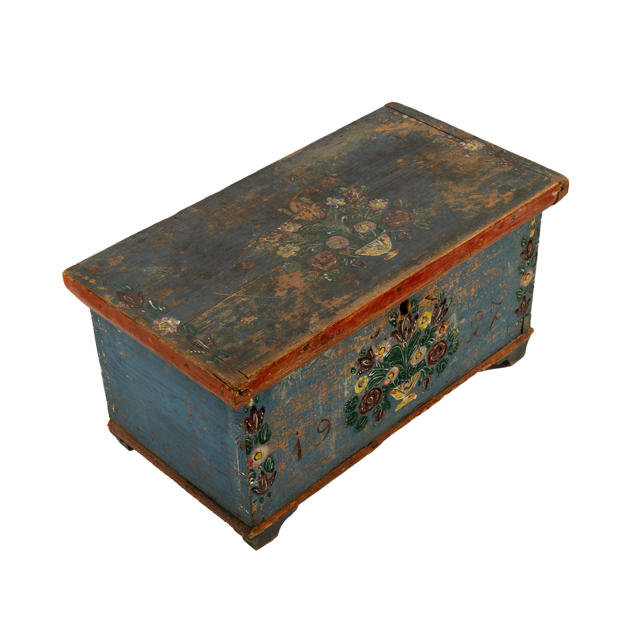
66. Saxon valuables box, decorated with floral elements, dated 1927
Starting price
EUR 400
0 Zile, 18 Ore, 37 Minute
Time remaining until live auction starts
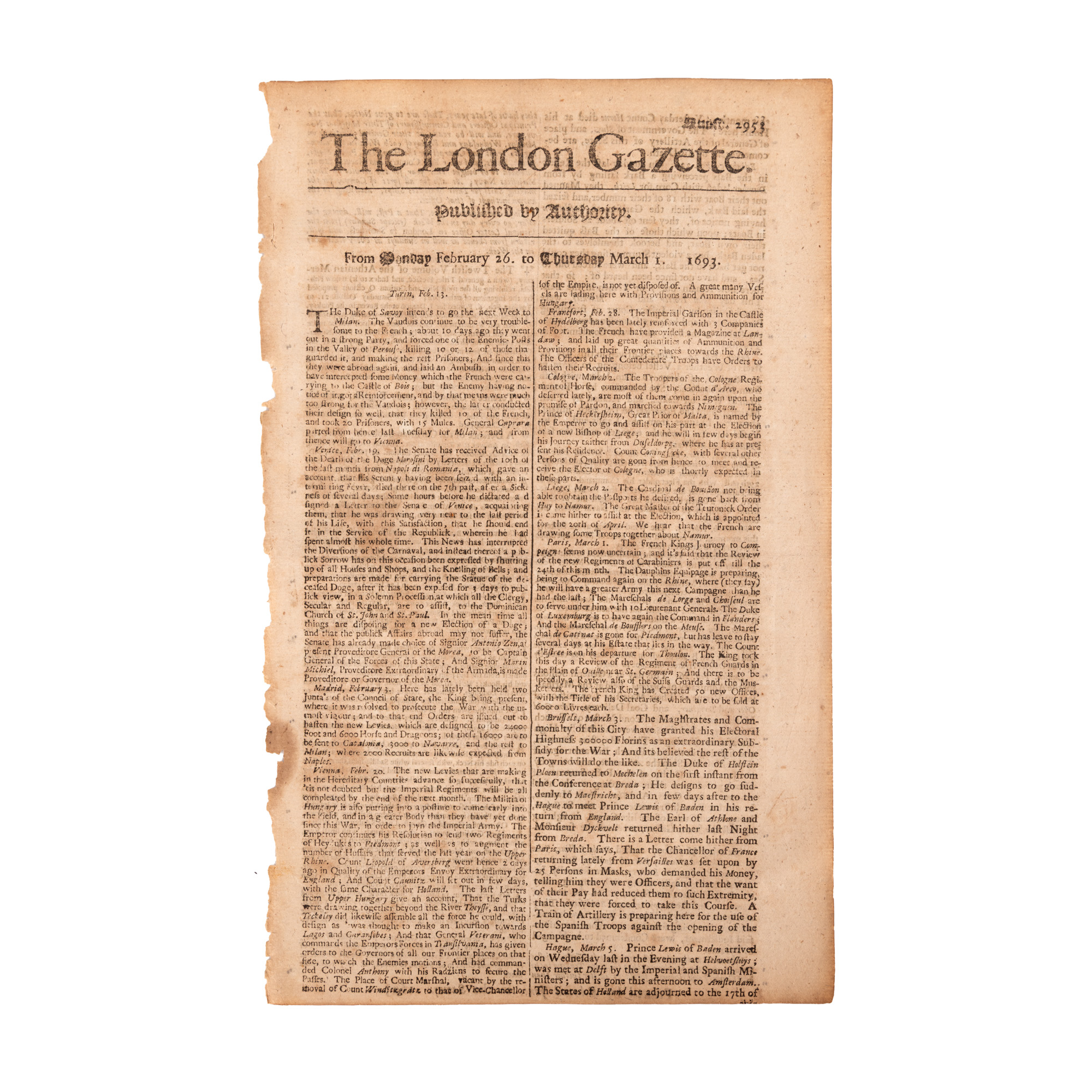
210. "The London Gazette", English, no. 2953, February 26-March 1, 1693, with information about the intention of the Transylvanian prince Imre Tekely to attack Lugoj and Caransebeș together with the Ottomans.
Starting price
EUR 150
0 Zile, 18 Ore, 37 Minute
Time remaining until live auction starts